


![]()
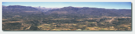
The Andes are the dominating feature of Peru. There are few places like it in the world: the Himilayas, the Alps and the Caucasus. This land mass shapes history and the future. Man is challenged to survive in this environment.
The Andes rise 6,000 meter or 19,700 feet above sea level, separating the Pacific Ocean and the Amazon jungle basin. From the depths of the Peru-Chile trench just off the Peruvian coast to the Andean peaks is a difference in altitude of more than 40,000 feet within a distance of 50 miles.
The chilly currents of the Pacific Ocean that flow out of the Peru-Chile Trench supercharges the coastal air with humidity, inhibiting rainfall. At most, a low, soupy overcasting covers the coast for six months a year. It makes Lima a depressing place.
The El Niño Current, now famous because of the latest eruption of the Pacific Ocean phenomenon, but Peru has had to deal with its whims and tantrums for centuries. Just one ramification is that the southern Sierra is periodically subjected to severe draughts every eight-ten years. The result is almost scheduled impoverishment for the peasants who lived in that region. I can remember visiting Puno and hearing stories of how villagers lost entire herds of llamas and alpaca. This livestock served as their savings account for survival and wellbeing. The draught was like a bankruptcy. That also makes Lake Titicaca even more important in the altiplano economy.
The Andes comprise about a third of Peru's territory. The extreme variables of altitude, temperature, moisture, sun light and other factors make the Andes a highly risky environment. The highest peak is Nevado Huascaran at 6,768 meters above sea level.
|
The most useful land is the slopes and plateaus higher than 2,000 meters above sea level. It is the ecological zone that holds most of the genetic diversity and staples of the Andean economy.
A consequence of the scattered population and steep terrain is that a government is hard pressed to provide services, like schools, health and infrastructure.
There is a serious question whether traditional capitalism and modern agriculture can prosper in this kind of environment. It's not possible to superimpose Kansas wheat and corn fields on the Andes, even if it was economically feasible. Many of the mistakes of the past century have been due to a lack of understanding of what kind of productive systems are needed in this region. Only 2.85% of the land is arable.
All this makes the achievements of the pre-Colombian cultures seem all the more astonishing. Culminating in the Pan-Andean realm of the Inca, this approach to using natural resources and tying together diverse production systems and human interest accomplished more than modern technology could. Only now are the government and development and environmental groups coming around to the conclusion that something different has to happen.
The unique, varied conditions of the coastal desert, the Andes and the Amazon rainforest have brought about a huge diversity of plant and animal life. Wildlife and plants
Earthquakes: earthquakes in the Andes. Full title is "Seismological and Tectonic Deformation Studies in the Central Andes and Seismic Hazard Evaluation in the Peru-Chile Border Region" ::: CERESIS the South American earthquake organization ::: Instituto Geofísico del Peru ::: Natural Disaster Profiles
El Niño: the National Oceanic and Atmospheric Administration's El Niño site. Its links page and educational page. ::: SENAMHI ::: El Niño - its Far-reaching Environmental Effects on Army Tactical Decision Aids
Glaciers: US Geological Survey - images and maps of 20 glaciers in the Peruvian Andes (1999). Note: the images are large and may take a while to download
Resources: Cajamarca Atlas ::: National Geographic Institute ::: National Institute of Natural Resources ::: Instituto del Mar del Peru ::: Geophysical Institute ::: Mountain Forum::: Consejo Nacional del Ambiente ::: Centro de Datos para la Conservación ::: Jicamarca Radio Observatory
![[ Map of Peru ]](../images/pe_map.gif)
One of the most illuminating moments for in understanding Peru and the Andes was looking at a map that showed altitude, but especially the areas above 2000 meters above sea level. In Peru, this zone is called the Quechua. It is the intermontane valleys where corn and other staple crops grow. In other words, the source of agriculture wealth. But the other zones above and below the Quechua also have importance in the subtle interplay of ecology and man. Even the Puna, the high steppes, where nothing but scrub grass and tough bushes grow, is vital as grazing land for the alpaca and llamas that provide meat and wool.